

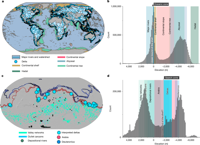
Planet-wide interpretations of shorelines suggest that Mars once hosted an early ocean covering one-third of its surface1–9. However, the elevations of these shorelines deviate from an equipotential surface by several kilometres, challenging that interpretation3,7,10–12. Here we investigate whether a planet that once hosted an ocean should be expected to leave discernible shorelines. We show that on Earth, the most prominent topographic signature of a global ocean is not a shoreline. Rather, it is a band of low slope and curvature values that comprises coastal plains and the continental shelf, with an elevation range of −410 m to −15 m. When applying a similar analysis to the Martian surface, we observe a comparably flat zone between approximately –1,800 m and –3,800 m elevation, potentially marking a partially preserved Martian coastal shelf. Although other processes, such as lava flows13, might explain flat regions locally, a coastal shelf best explains the circumglobal band of flat topography, in addition to river delta deposits4,14–17, coastal deposits18, thick sequences of layered rock19,20 and aqueously altered minerals20,21, all observed within the putative coastal shelf zone. Our results support the presence of an ancient ocean on Mars and indicate that topographic shelves rather than shorelines may be better indicators of long-lived oceans. Shelves rather than shorelines may be better topographic indicators of oceans on Earth and Mars. Continental shelves on Earth have been defined regionally using diverse criteria and expert knowledge and compiled into a global map42 (Fig. 1a). Here, we sought quantitative topographic metrics that can be used to distinguish the continental shelves... [27822 chars]


2026 Copyright © News-Matic.com. All Rights Reserved